Author Archives: donsbrother4

ME 17, Oquossoc, ME

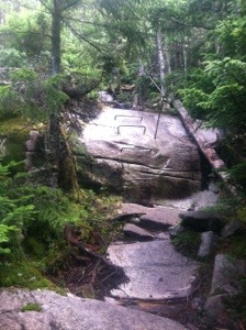
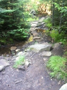
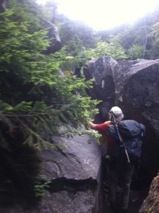
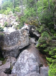
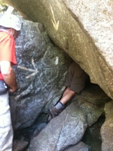
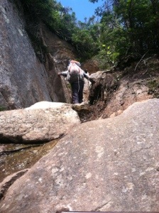
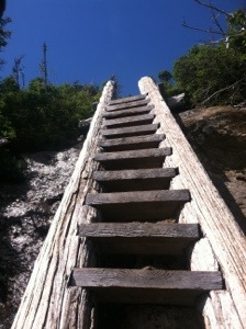
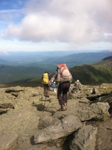
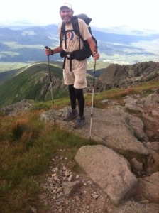
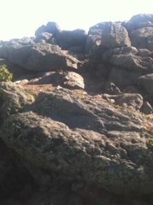
Old Blue conjures up the image of a docile, sleepy hound dog waiting for a pat on the head, kind of like Old Duke in The Beverly Hillbillies. Old Blue, the Appalachian Trail mountain in Maine, in no way resembled a lethargic canine. It greeted Molar Man, Susquehanna Slim, and me at 7:07 with an immediate steep rock step incline. Despite the neatly arranged steps that had obviously required many hours of trail maintenance, Old Blue brought out the sweat early. When the steps diminished, the sheer rock face commenced. Some nice person had fortunately placed rebar ladders with railings in strategic places. When no rebar was available, I inched my way up the slabs, hugging the small trees for balance if I could find one.

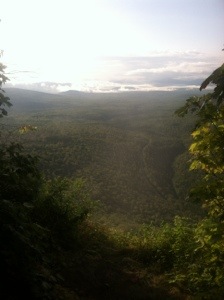
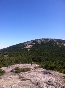
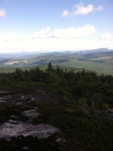
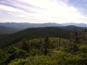
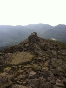
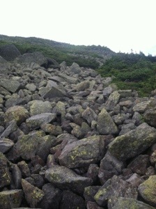
Reaching the summit after climbing 2200 feet over 2.8 miles, I was already tired with 10.4 remaining to be hiked. Then a painstakingly slow descent followed. Every time a downhill occurs my pace decreases. With massive amounts of mud to contend with, in addition to the steep slick rocks, deliberate hiking was a must. And when I slowed, my hiking buddies got ahead. It’s just my method to try my best to ensure that I stay on my feet. On a few occasions I still needed to sit and slide down a slippery, mossy rock. I don’t mind sitting when that’s the best way.

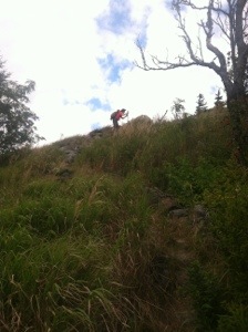
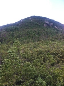
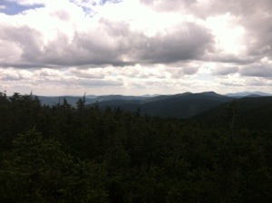
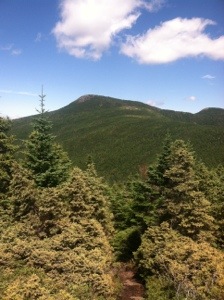
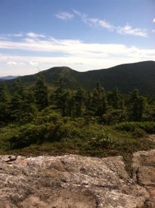
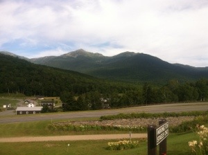
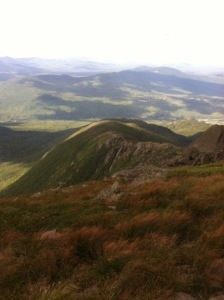
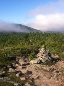
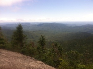
After the slow descent I had to climb what seemed like a never ending Bemis Mountain. We thought we had reached the summit about four times before we finally did. Even though there was no view due to cloud cover, we took our lunch break at the top. Pumpkin Head, Sinner, and Torch passed us as we ate. We also were passed by Stretch and Barking Spider later in the day.

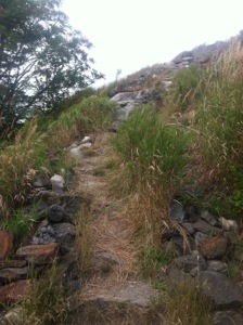
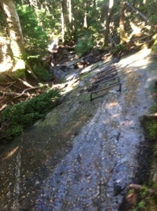
The remainder of the day consisted of several ups and downs over the same tedious terrain. Like yesterday, both my shoes were caked in thick black mud. Wet roots contributed to the less than agreeable trail. Feeling tired early in the afternoon made the final four miles difficult in more ways than one. Molar Man hiked ahead while Slim and I lagged behind, talking our time on the final steep downhill. When it ended the trail had one more special offering for our final mile of the day, another steep climb. This one, fortunately, ended at the road.

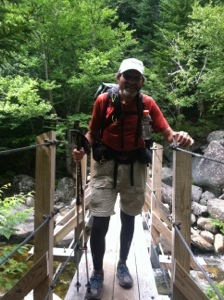
Slim and I walked up the highway to where the Volvo was parked. We quickly realized that Molar Man had fallen into the last stream crossing of the day. A haggard looking man, who identified himself as a homeless trout fisherman, even offered Molar Man some dry pants. He declined. The fisherman kept insisting, saying that they were recently laundered. Sweet Tooth told the man they weren’t the right size. If Molar Man had accepted the man’s generosity, that would have been a different type of trail magic.

Today indeed was a tiring one. The trail threw some challenges our way, but we were up for them. As I hiked today I thought a lot about my brother. A year ago today Don had exactly two weeks left to live. A man of strong faith, he was ready to move on. I thought about the inner strength he continued to reveal up until the end. Daily as I walk I feel his strength with me. I’m getting close brother. Just a little while longer on the Appalachian Trail.

20130814-212136.jpg

20130814-212156.jpg

20130814-212208.jpg

20130814-212224.jpg

20130814-212240.jpg

20130814-212252.jpg

20130814-212302.jpg

20130814-212313.jpg

Categories: AT Hike | 1 Comment

South Arm Rd., Andover, Maine

I’m sitting at the lunch counter of the General Store and Diner in Andover. Susquehanna Slim occupies the stool to my left. Molar Man and Sweet Tooth are to my right. Our feet relax on red plastic milk crates. The crates keep our legs from dangling. It is 6:15. I’ve been awake since 5:30. The weather reporter on the wall mounted TV notes that rain is in the forecast. Radar indicating a band of dark green, yellow, and orange verifies her statement. The rain will begin around noon. Our planned hike today should conclude before 2:00. We will most likely get wet.

To Sweet Tooth’s right is a “regular.” In fact, all the customers except the four of us are. We are the interlopers. Still I feel welcome among these western Mainers. We are easily recognized as hikers. Many of the customers have lived here their entire lives. The man next to Sweet Tooth talks about driving up to northern Maine today on business. Caribou, he mentions. I tell him I spent a week there several years ago. He talks about his state pridefully. My friends and I order breakfast, not really blending in, but accepted. The General Store and Diner is a good place to be on an overcast, cool August morning in Maine.

Too soon we drive away, toward the trail and another day of hiking. At 7:01 I take my first step into the woods from East B Hill Rd. Within a few steps I am climbing. The trail ascends over 600 feet to Surplus Pond. I pause to take a picture, thinking about my brother. This looks like a perfect spot for a moose. I see none even though we have been told many inhabit the area. After the pond we continue to climb another 800 feet up Wyman Mountain. Despite the lengthy uphill, the trail is agreeable. There are still roots and long stretches of black mud. I try to avoid each squishy patch. Eventually I take a misstep. My right blue trail runner is transformed to a charcoal grey.

Molar Man and Slim hike ahead. I linger, enjoying the opportunity to finally let my mind wander. I have had to concentrate so often that my mind has felt fatigued. Today the gentle trail affords me the opportunity to daydream. With few views, my thoughts become a luxury. I remember other trail days, friends I have made along the way, places I have visited and will probably never see again. My thoughts and I hike alone down Wyman Mountain to the Hall Mountain Lean-to. I arrive there at 10:07, having hiked the six miles steadily. Molar Man and Slim are having a snack.

After a ten minute break we descend over 1500 feet sharply to Sawyer Notch. I suggest the name game again, but neither of my hiking buddies has an entry. Tom and Diane are the only two I can offer. So I suddenly find myself hiking deliberately again, needing to focus on every step as I carefully navigate the steep descent. Occasional rock steps help alleviate some of the stress on the knees. Slippery oozing mud lurks around every bend waiting to “suck up” an unsuspecting shoe. Then when I finally reach the bottom, the climb up Moody Mountain begins and a steep one it is indeed.

Near the summit of Moody we are treated to our only view of the day, and it is short lived. Just when we reach the overlook, clouds engulf the area. As soon as I snap a pic the view disappears. The light rainfall increases as we start our descent. Like the downhill earlier in the day, this one also necessitates my utmost attention. Several times I come within a step of taking a fall on the slick mud. Each time I maintain my balance at the last instant. With some rock steps, all things considered, the descent goes well.

When I finally reach the bottom of the hill a final stream crossing awaits. We had been warned that a fording would be necessary at this water crossing before the road. Molar Man and Slim, however, are on the other side, having rock hopped across. With specific instructions on which rocks to use, I successfully make my way to the other side without stepping in the water. It really doesn’t matter since my shoes are covered in wet mud. Still it feels good to have made my way over two streams and stayed dry. With Sweet Tooth waiting, the four of us are quickly on our way back to the Cabin.

Tonight I enjoyed another delicious meal prepared by Honey. Some hikers took a zero due to the rain and are still here. Other new ones have arrived. I have met Rocky and Steady State for the first time. Star Child, Splash, Sinner, Torch, Slow and Steady, Pumpkin Head, and Spacey also are in attendance. Good company and great food abound. Tomorrow is supposed to be sunny. For that matter, sunny skies are predicted for the next few days. If the weather continues to be good, and the terrain remains agreeable, hopefully I’ll be able to cover more miles as I move toward completion of the Appalachian Trail.

20130813-211149.jpg

20130813-211157.jpg

20130813-211206.jpg

20130813-211215.jpg

Categories: AT Hike | 1 Comment

East B Hill Rd.

On another beautiful, sunny, mild Maine day I found myself hiking happy again. With a less difficult trail to traverse today, and a slack pack for the first time in over two weeks, Molar Man, Susquehanna Slim, and I covered the 10.3 miles from Grafton Notch to East B Hill Rd. in right at seven hours. That even included a thirty minute break for lunch at the Frye Notch Lean-to. Throughout the day I enjoyed the company, I enjoyed the views, but more importantly I just enjoyed hiking. All in all, it was a good day to be on the trail.

From the outset at Grafton Notch my hiking buddies and I were faced with the only challenging part of the day, the climb to the west peak of Baldpate at 3662 feet. Most of the ascent consisted of “regular” trail even though an occasional sheer rock face appeared. I regained some of my hiking composure and walked up most rather than hugging the tree-line. Since the rocks were relatively dry and not too slanted, this method of hiking proved somewhat easier. Even over a few rocks that were still slightly wet, I maintained this approach, following closely behind Molar Man and Slim.

After reaching the west peak of Baldpate we crossed a short notch before climbing up the east peak. The east peak posed more of a challenge, but not one I wasn’t up to today. I put my head down and steadily walked up the creviced rock face to the summit at 3810 feet. Views from the top extended for several peaks to the west including the presidential range in the Whites. Mt. Washington was even visible with only its summit in the clouds. I don’t know how many miles could be seen, but it had to be close to one hundred with blue skies in all directions. I stared into the distance with awe. Again, the views were beyond spectacular.

From the east peak of Baldpate we descended about 1500 feet to the Frye Notch Lean-to, where we stopped for lunch. In Maine the word Lean-to is used in place of shelter. They are still the same three sided wooden structures that usually sleep between 6 and 12. After the break we ascended briefly a “no-name” mountain. I like these mountains without identities. They mostly are nondescript and pose little difficulty. Views are nice; however, sometimes it’s also good to have a break from the challenging ascents. All the mountains that may be dangerous have names. After the short climb we descended another agreeable section of trail to Dunn Notch and Falls. Several water crossings occurred, but all had well-placed rocks for hopping across. I managed to stay vertical and dry throughout the hike.

We took our last break at the falls. As usual I leaned my hiking poles against a tree. Apparently a gust of wind knocked one down toward the water. Fortunately it hung up on the way down and Slim was able to retrieve it. While there we met Blondie, a southbound thru hiker doing a northbound slack pack today. He passed us on the walk to East B Hill Rd. and rode back to the Cabin with the rest of us. The only northbound thru hiker I saw all day was Spacey.

So I’m suddenly just as encouraged about hiking today as I was discouraged after yesterday’s more treacherous section. With 256.9 miles still remaining I certainly needed a morale boost. I think Baldpate gave it to me. It’s only a little before 5:00. I’ve had a good hike, showered, and am about to finish this journal entry. Honey and Bear will serve supper in about an hour. A cool breeze filters through the trees. All is well because I’m hiking happy again, headed north on the Appalachian Trail.

20130812-170714.jpg

20130812-170723.jpg

20130812-170734.jpg

20130812-170742.jpg

20130812-170749.jpg

20130812-170757.jpg

20130812-170805.jpg

20130812-170813.jpg

20130812-170821.jpg

20130812-170829.jpg

Categories: AT Hike | 4 Comments

Grafton Notch

It’s past 9:00 PM. I’m at the brink of exhaustion, yet I need to write and post today’s entry. I hope to be asleep within the next two hours. If I closed my eyes I would be in two minutes. It has been a physically and mentally tiring day. With only 267.2 miles until the finish line, it seems like I should be getting ready to celebrate. Instead I continue to find myself facing difficult challenges and often in precarious situations every day. There’s no way to enjoy what I am doing due to the stress I am under. If folks really want to know what thru hiking the AT is all about, I can sum it up in one word: hard. Make that HARD.

After a restless night’s sleep at the Full Goose Shelter, I awoke at first light. Molar Man was already dressed and ready to hike. Susquehanna Slim was getting ready. Pilgrim still snoozed in his sleeping bag. Begrudgingly I forced myself from my cozy bedding to ready myself for a day I had been dreading. My fears would soon be realized as I hiked what easily was one of my five toughest days on the trail. A good description would be somewhere between treacherous and brutal. For those who have hiked this section and describe it otherwise, my apologies.

So after a less than nutritious breakfast my buddies and I headed up the trail toward the Mahoosuc Notch, reputedly the hardest mile on the Appalachian Trail. The duration of the notch from the south end to the north end actually covers 1.3 miles. It would take us almost two hours to complete the infamous section. Some call it a fun mile. I may have too in my youth when I still possessed agility. It was definitely different climbing through, over, and under the boulder maze. We stayed together during the scramble, each offering suggestions for the most passable route. For the most part we chose to go over the giant rocks. Only once did we have to remove our packs to crawl through.

When the traverse finally ended we were immediately confronted with the Mahoosuc Arm, a lengthy ascent with long segments of sheer rock face to walk, climb, or crawl up. Like many other times, I clung to trees on the erosion line when the opportunity existed. Pulling myself up using spindly trees or roots afforded me the safest passage up the mountain. Within about a half mile from the summit we paused for lunch. Sitting in the middle of the trail on a rock, I thought about how tired and miserable I felt with over half the hike remaining. It was a challenge getting going again.

After the Arm there was no break. We then had to deal with Old Speck, a mountain I had not even expected to be a challenge. I was dead wrong. Exposed rock face near the summit required precision rock climbing. There appeared to be no room for error. At one point I stood almost petrified staring upward at a jagged rock that had to be climbed. As I pondered what to do, Burning Man happened to show up. The route he took looked like the safest so I followed. It was a relief to get past this section. The beauty of Speck Pond offered the only positive for the entire day.

Eventually we reached Speck Pond Shelter which left 3.8 miles to Grafton Notch. Those miles proved to be the most agreeable of the entire day. With a sane trail again, we quickly made our way to the notch and road. Sweet Tooth had not yet arrived, so Slim, Pilgrim, and I waited while Molar Man hitched a ride to Bethel where he could get cell service to call her. When we finally did her back to the Cabin, Honey had gratefully saved us some supper. Four tired hikers ate well.

So far Maine has been just as difficult as New Hampshire. I knew it was going to be tough. I just thought I would be able to hike without stress again. So far agreeable trail has been limited. It has been fortunate for me, however, that every time I find myself in a very real predicament, someone comes along to help. When I saw Speck pond today I thought of Don. I know that when others aren’t around, he is. Today was again a challenge. Tomorrow may be as well. But regardless of the difficulty, I’m still making my way northward, slowly but steadily, on the Appalachian Trail.

20130811-221212.jpg

20130811-221241.jpg

20130811-221249.jpg

20130811-221224.jpg

20130811-221257.jpg

20130811-221310.jpg

20130811-221319.jpg

20130811-221331.jpg

20130811-221339.jpg

Categories: AT Hike | Leave a comment

Full Goose Shelter

Saturday, August 10: On a sunny, mild, windy day I entered my 14th and last state on the Appalachian Trial. Along with Pilgrim, Susquehanna Slim, and Molar Man, I also passed the 1900 mile mark. So as I sit in the Full Goose Shelter this evening, I’ve found myself thinking back on some early days on the trail. On what should be a cold night, I commented to Molar Man that I’m glad we’re not in the Smokies. It was at Spence Field Shelter that we first met. Seems like years ago. Time continues to have little relevance on the AT.

My day began when the alarm on my watch sounded at 3:30. Since we wanted breakfast and an early start, the before dawn beginning to the day was necessary. Plus we had to hike the 3.5 miles back to the Gentian Pond Shelter on the Austin Brook Trail and the 0.2 from the shelter to the AT. We only get credit for a 9.6 mile day even though we hiked a total of 13.3 miles. The miles on the Austin Brook trail went quickly. We then stopped briefly at the shelter before heading on to the AT. Pumpkin Head, a northbounder that I had heard of but never met, and Spacey were still there. When we did finally begin the AT portion of the day it was 7:48.

Throughout the day the trail offered a variety of difficulties. We climbed Mt. Success, Mt. Carlo, and the west, east, and north peaks of Goose Eye Mountain. And of course every time we ascended, we had to descend. Each mountain posed some type of challenge. From slippery, wet rock faces that required pulling myself up ledges, to straight, dangerous rock slabs I had to try to gingery walk or slide down hanging on to trees on the erosion line, the trail didn’t really offer up anything new. We left New Hampshire with a short rocky ascent and were greeted in Maine with a climb up Mt. Carlo. All in all the trail still demanded respect and focus.

By far the biggest challenge of the day came on the west peak of Goose Eye Mountain. Some of the rocks were so steep that rebar had been drilled into the rocks. After climbing up the rebar I still had to hoist myself up on top of the slab. When we finally reached the summit of West peak, the wind gusts had to be at least 60 MPH. I had a difficult time just standing. Due to the wind I didn’t pause. It was important to get back below tree-line as quickly as possible.

In addition to the wind, extensive bogs of squishy black mud appeared on almost every flat area of trail. Slim and I both made the mistake of stepping in the oozing substance. It literally came up to our knees. On numerous occasions I walked several yards off trail to try to avoid the quagmire. It was a downright nuisance. Plus many of the boards over the boggy sections were submerged due to yesterday’s hard rain. If it’s not one thing, it’s another on the AT. From slippery roots and rocks to jagged rock faces, to the oozing mud and puddling water, it seems like there is constantly an obstacle around every bend.

Yet despite the challenges I have made it to Maine. Darkness is approaching and the shelter is steadily filling. Thru hikers headed north meet hikers headed south. Trashcan, Hoops, Spacey, Burning Man, Acunamatata, and others whose names I didn’t get are here. A pleasant group has assembled. Stories are being shared. The AT community is family. Everyone is willing to make a little shelter space for late arrivers. So as I settle in for the evening all is good. Tomorrow my buddies and I will tackle what all consider the most difficult mile on the AT as I hike my second day in Maine on the Appalachian Trail.

20130811-203357.jpg

20130811-203407.jpg

20130811-203418.jpg

20130811-203428.jpg

20130811-203441.jpg

20130811-203452.jpg

20130811-203511.jpg

20130811-203524.jpg

20130811-203539.jpg

Categories: AT Hike | Leave a comment

The Cabin

Hard rain awoke me in the middle of the night. At daylight a steady drizzle continued. Young Padawan walked away from the shelter as the rain’s intensity increased. With a 9.6 day planned, which included going over potentially dangerous, slippery rock slabs on Success and Goose Eye Mountains, we hesitatingly changed our plans. Pilgrim has been experiencing troubling back pain for almost a week. Molar Man, Slim, and I agreed with him that hiking today bordered on insanity. Our two options were to zero at the shelter or hike the 3.5 mile Austin Brook Trail to a road where we could get a shuttle to Andover, ME. We opted for the second.

So in a light rain we bailed for today to the alternate trail. Earl from the Cabin said he could pick us up at North Rd. around 10:00. Over some slick rock faces, on a trail that had overnight transformed into a stream, we headed to the road and safety. Fortunately the rain subsided for the most part during the two hour walk. The trail eventually became a very agreeable woods road for about the final two miles. Despite the slippery roots and standing water, we hiked rather quickly.

The only difficulty with the alternate trail was the water crossings. Due to the heavy rains, stepping stone rocks had become submerged. At one stream I slipped from a rock into the water. Since my feet were already wet I didn’t worry about the other streams. When I didn’t feel like I could plant my foot safely on a rock, I just stepped in the water. This occurred three times. I think we all got our feet wet before we reached North Rd. When we did get there we had to wait for Earl.

Just before another hard downpour he arrived to shuttle us to the Cabin in Andover. Earl and Marge have been welcoming hikers for nineteen years. Both hikers themselves, they also are more than willing to share a wealth of trail knowledge with anyone who cares to listen. Honey and Bear, their trail identities, are some of the most genuinely kind and sincere folks I have met since I started the hike. They open their main home to hikers and even offer breakfast and supper for extremely modest prices. The bunk house, which is attached to the home, sleeps eight. Susquehanna Slim, Pilgrim, and I got the last three bunks. Molar Man and Sweet Tooth were able to land the one private room.

After cleaning up we all drove to The Red Hen for lunch. The continued hard rain didn’t deter us from an enjoyable meal. I topped mine off with a piece of homemade blueberry pie. For the rest of the afternoon I just rested. I took a nap and chatted with other hikers. Now I’m about to join the others for supper. Then it’s off to bed. So tomorrow and the next few days are predicted to be sunny. I’ll arise at 3:30. Molar man wants to get an early start. We’ll have another extremely challenging day over Mt. Success and Goose Eye Mountain as I keep working my way north up the Appalachian Trail.

20130809-174727.jpg

Categories: AT Hike | 1 Comment

Gentian Pond Shelter

I’m sitting in the Gentian Pond Shelter. It is raining. I have been here since before 4:00. It’s going to be a long night. There are three SOBO’s here: Prism, Foxy, and the Doctor. Prism had not heard of her namesake in The Importance of Being Earnest. She has much information to offer about Maine. Many of her descriptions are in the form of warnings. I keep telling her I am not interested. She keeps talking anyway. Northbounder Padawan, a high schooler from Florida, just walked up, drenched. The shelter sleeps 14, so there is plenty of room. Others may also arrive. It could get crowded. Time will tell.

With the Whites now history, I awoke in a much more relaxed frame of mind this morning. Pilgrim, Susquehanna Slim, and I rode with Molar Man and Sweet Tooth back to the trail at about 7:30. The first mile of today’s hike was on two roads. When we finally reached the woods, a 1700 ascent of Mt. Hayes greeted us. Most of the trail consisted of smaller rocks, dirt, roots, and mud. In other words, the AT of Vermont has returned. I did not complain. After the treacherous terrain in the Whites, I welcomed the mundane tree-lined trail of today.

When we reached the summit of Mt. Hayes we took a break. Slim wondered if the mountain was named for Rutherford B. Hayes. Perhaps since he missed the Presidentials, maybe he was assigned to a lesser mountain. We went on to suggest other prominent Hayes’. Helen Hayes, Isaac Hayes, Gabby Hayes, and “Bullet” Bob Hayes were also choices. We thru hikers continue to struggle for worthwhile conversation at times. So on we hiked toward Cascade Mountain.

The trail continued to be agreeable for the most part; however, some sections of rock slabs that required the use of hands still existed. Whether up or down, they took more time. Even though the trail for most of the day presented few difficulties, it still took us seven hours to hike the 11.8 miles. We did take several breaks. We also passed three beautiful ponds. Each made me think about my brother. They seemed so peaceful and isolated.

So now there are still three hours to good dark, and there’s really nothing to do. If I get in my sleeping bag now, I’ll fall asleep and wake up at ten or eleven. Then I’ll lie awake until past midnight. There is no good way to relax in a shelter. But I am dry and among interesting people. This is also my last night in New Hampshire. We are 4.7 miles from the Maine border. Even though the next few days will still be tough, at least I’ll be in the final state. About three more weeks on the Appalachian Trail.

20130808-181914.jpg

20130808-181924.jpg

20130808-181945.jpg

20130808-181905.jpg

20130808-181932.jpg

Categories: AT Hike | 2 Comments

Pinkham Notch

The Whites are done….and I survived. On another postcard like day, I hiked up and over arguably the most difficult mountain in the Presidential Range, Mt. Madison. It was tough. No, it was beyond tough. It was ridiculously difficult. It is a mountain I may admire at a distance in the future. It is a mountain I never intend to step foot on again. Once was definitely enough. On that stress level of 1-10, this time I hit about a 15. With focused, deliberate steps, I managed to stay upright. Still it took almost two hours (1:50 to be exact) to reach the summit from the Madison Spring Hut. Distance: exactly one mile. And after reaching the summit, there still remained the equally nerve wrenching descent. It was tough, even rougher than the climb, but I did survive.

The day started with another pots and pans clamoring in the kitchen at Madison Spring Hut at 5:30. We thru hikers who were sleeping in the dining area had to pack up and be gone by 6:30 when the tables were set for the paying guests. I had pushed two benches together to make myself a bed last night and slept rather well. After packing my gear and consuming two pop tarts and some cheese with a cup of hot tea I purchased for $1.00, I was out the door. Official start time for today’s hike was 6:44. Since Molar Man wanted to do some reconnaissance work for the next few days, he and Susquehanna Slim left about a half hour earlier.

Looking up at the massive Mt. Madison made me a bit queasy even before I began the ascent. A sea of various size boulders, many at a variety of angles, awaited my every step. Few were flat. Many required hand maneuvering to navigate. Each offered a challenge. A false step at any moment could have proven disastrous. I walked carefully, often using my hands to steady myself. I even telescoped down one pole and placed it in my pack. That allowed me to have one free hand at all times. The painstakingly slow climb played on the nerves. Still I paused often to admire the views in all directions. The day was so clear that the buildings on Mt. Washington were visible.

Throughout the morning Pilgrim hiked ahead and waited every few minutes.
After over three hours we finally found ourselves below tree-line. The steep downhill continued, but at least trees lined each side of the trail. A stepping stone pattern offered an easier descent at times. At others rock faces required more thought. Occasionally, although rarely, a level portion of trail appeared. Usually it was short-lived and often muddy. Even in the Whites, black mud happens. Despite the mud, these brief respites were appreciated. It was over four hours into the hike when Pilgrim and I finally reached the Osgood Trail intersection. We had walked three miles.

About this time we caught Bird and Bella, a hiker from Pensacola. I hiked behind them for much of the afternoon and enjoyed chatting with Bella. She told me that she had recently retired from the US Navy. I also met southbounder Potter, a young man from Tennessee. Potter is a potter who said he had started his thru hike exactly a month ago today.

So as the afternoon progressed the trail became more agreeable. At each intersection Pilgrim and I conferenced to make sure we were on the AT. Blazes are often infrequent in New Hampshire, and the AT coincides with other named trails. The final trail it uses before reaching Pinkham Notch is the Old Jackson Rd. Trail. This trail crosses the Auto Rd. to Mt. Washington. Pilgrim and I took our final break here before “taking it to the house.” The trail gratefully transformed into a “trail” again for those last two miles.

When we reached the visitors’ center at Pinkham Notch, I phoned Maryann at the motel/hostel for a shuttle. Bird and Bella shared it into Gorham. Slim already had a room and had bought some special snacks for Pilgrim and me. Later we went out to eat and then to Walmart to re-supply for two nights in the woods. I am about to be in one of the most remote parts of the entire trail, so my entries may not be as forthcoming over the next few days. I just don’t know. I’ll keep writing and post when I have service. As I get ready to head into Maine, I continue to appreciate all the support and prayers. After tomorrow, one ore state on the Appalachian Trail.

20130807-224529.jpg

20130807-224537.jpg

20130807-224546.jpg

20130807-224600.jpg

20130807-224610.jpg

20130807-224620.jpg

20130807-224628.jpg

20130807-224640.jpg

20130807-224650.jpg

Categories: AT Hike | Leave a comment

Madison Spring Hut

Molar Man made his debut as the new fourth member of the Rawhide gang in the Mt. Washington to Madison Spring Hut episode today. On a beautiful, sunny 42 degree morning, visibility at the summit was listed at 120 miles. A worker said there are only about six days a year with this nice a forecast. Our decision to forgo this 13.5 mile stretch until today and tomorrow turned out to be an outstanding one. The summit we experienced today compared in no way with the Mt. Washington of last Saturday when visibility was listed at 75 feet. After a day in the clouds then, we enjoyed panoramic views throughout the day today. The awe inspiring vistas made me appreciate God’s creation to its fullest. Again I don’t think there are suitable adjectives to describe the enormity of the landscape.

My day began with breakfast at McDonalds in Gorham with Molar Man, Sweet Tooth, Susquehanna Slim, and Pilgrim. After the meal we drove to the auto road at the base of Mt. Washington. At 9:00 our van driver Dexter drove us to the summit. We started the descent northward on the AT a little before ten. Almost immediately Molar Man and Slim put distance between themselves and Pilgrim and me. I hiked deliberately from the outset, paying close attention to each footfall. The trail consisted of moderate size boulders slanted at various angles. The downhill always presents a greater challenge for me which is why my pace was slow all day.

As we hiked off the summit of Mt. Washington, the cog railroad ran parallel to the trail. All the remaining mountains in the Presidential Range loomed in the distance. I admired with respect and reverence the prodigious formations. Over the course of the 5.7 mile day I would hike near the summit of Mt. Clay, Mt. Jefferson, and Mt. Adams. The rocky terrain made the miles go slowly, but that mattered little with the scenery I was experiencing. Every few minutes I would just stop and admire. I also talked with a few southbound thru hikers. Taxi had been at the Carter North Hut with us two nights ago.

About a mile before reaching the Madison Spring Hut, I met day hiker Emerald from Vermont. A retired teacher, he told me that he was working on completing something called “the grid.” He hopes to climb each of the 48 4000 foot mountains in each month. I told him I’m motivating myself these days with the motto, “Every step I take is a step I will never have to take again.” I can’t imagine climbing each of these New Hampshire mountains in every month. The thought fatigues my mind even more than it already is. I really appreciated Emerald’s company over about half a mile.

Just past the intersection with the Airline Trail, I reached a peak where I could see the Madison Spring Hut in a valley. When I arrived all my buddies were already there. We had the option of work for stay or to pay $10 for leftover food and a space to sleep on the floor. We opted to pay. Still we have to wait until 7:45 to eat. Hey, it’s a roof and much nicer than a shelter. This is my fourth hut. I’ve been a paying guest twice and eaten after the guests twice. The main difference is the temperature of the food. That’s the only downside. Our food will be cold.

So as I type this the guests are being served. It smells good. My buddies and I have been relegated to a table in the corner with no food. It beats standing outside in the cold. More importantly, I’m among good company. Another thru hiker, Bird, who is from Germany, has joined us at our table. Stretch and Barking Spider also just arrived as did Restless Cowboy that I last saw in CT. This is a different Barking Spider from the one I met in the Shenandoah’s. As I wait to eat I’m chatting with Clark, a young man with an interest in writing. At least I have a view of the mountain ranges in the distance. It’s all good. Tomorrow I’ll hike back to Pinkham Notch, leaving only 16.5 miles to Maine on the Appalachian Trail.

20130807-164737.jpg

20130807-164748.jpg

20130807-164804.jpg

20130807-164814.jpg

20130807-164825.jpg

20130807-164834.jpg

20130807-164845.jpg

20130807-164856.jpg

20130807-164912.jpg

20130807-164923.jpg

Categories: AT Hike | Leave a comment

US 2, Gorham, NH

Howling winds awoke me several times throughout the night. When my watch alarm sounded at 5:00, a blustery day awaited. It took a tremendous amount of determination to leave the comfort and safety of Carter Notch Hut for a day in the elements. When Pilgrim, Susquehanna Slim, and I departed from our overnight accommodations, the wind chill was below freezing and wind gusts on the peaks were expected to reach 60 MPH. Fortunately there was no rain in the forecast. I began the day in running tights under my hiking shorts, a fleece, my rain jacket, gloves, and a toboggan. It was downright cold!

The hike today began with a climb up to Carter Dome at 4832 feet. At the summit the wind gusts made it impossible to stay very long. From Carter Dome we descended briefly before summiting another 4000 footer, Mt. Hight. It was here that we made a tactical error, or should I say another tactical error. When we reached the summit we took the wrong trail off the top and inadvertently hiked in a circle for about a mile, eventually standing by a trail sign that we had already passed. It was disheartening to have to repeat a portion of trail, especially since we were only hiking about a mile an hour.

When we got going in the right direction, we walked through Zeta Pass before summiting two more 4000 footers, Middle Carter Mountain and North Carter Mountain. The surprise of the day came on the descent of North Carter. We were greeted with a series of extremely slick, dangerous rock slabs. On a scale of 1-10 my stress level registered about a 12. Perilous is an understatement. To try to keep from falling to my …….., I hugged the tree line at times and at others sat down and inched myself down the wet, slippery rocks. It was nerve wrenching.

By the time we got to the trail to the Imp Campsite, it was past 1:30. We had only hiked 6.9 miles in almost seven hours. Realizing we still had 8.0 miles to hike and less than seven hours of light, we considered our options. The preferable one was to reach US 2 and a motel room in Gorham. Option two was to stop at the Rattle River Shelter, a little less than two miles from the road. Darkness would dictate out decision. After the trail to Imp we were confronted with one more climb, 3991 foot Mt. Mariah. With only a few stretches that required rock climbing, we reached its peak around 3:15.

From there the trail became much more agreeable. Running parallel to the Rattle River for a while, and crossing the river twice, the trail finally allowed my stress level to fall back to a 1 for the remainder of the afternoon. The final three miles, in fact, consisted of a gentle path. It was the first I can remember in the Whites. So Slim set his three mile an hour pace as we headed for the road. We reached it a little before 7:00, still meaning it had taken 13 hours to hike 14.9 miles.

When we arrived at the road Slim phoned Bruno for a shuttle. In the meantime a car with Tennessee plates stopped to ask if we needed a ride. When Bruno showed up in his small truck Pilgrim and I took the offer from Rainman. Rainman and Professor plan to continue a section hike tomorrow on Mt. Washington, which will end in a few days at Grafton Notch in Maine. Slim rode with Bruno. When we got to the hostel my buddies and I decided to upgrade to a motel room with three beds.

Today proved to be another challenging one. The steep, rocky descents and ascents can unnerve even the most seasoned hiker. For me, they can be downright petrifying. Every time I find myself in a precarious position, I think that I just want to be on firm ground at sea level again. Then when I get to town I have to immediately begin getting myself prepared mentally for another day of danger. The Georgia poet James Dickey once said, “if you’re bored with life, risk it.” I’m not bored, but sometimes I surely feel like I’m putting it on the line. So tomorrow I’ll head back up to Mt. Washington to walk north off its summit up the Appalachian Trail.

20130805-233249.jpg

20130805-233258.jpg

20130805-233309.jpg

20130805-233321.jpg

20130805-233330.jpg

Categories: AT Hike | 2 Comments

Blog at WordPress.com.